Making of the Swatara Watershed Map
- Meg Lemieur

- Sep 29, 2025
- 4 min read
From June to October in 2025, I have been the Artist in Residence with the Pennsylvania Environmental Council, hosted by the Swatara Watershed Association. I have so much to share about that time, but in this post, I'm going to share the nuts and bolts about how I created the illustrated map of the Swatara Watershed.

One of the goals of my Artist Residency was to create a piece of artwork that the general public could participate in, both in the making of it and the completed artwork. I proposed creating a beautifully illustrated map that offers a personal connection for the viewer, raises awareness about the watershed, and encourages engagement and stewardship of the river and its trails both on and off the water.
To create this map, I connected with local trail tenders and watershed experts to collect information about the watershed, trails, and local history both recent and deep. I also read multiple books about local history that centers around the Creek. Throughout my Residency, I hiked many local trails, kayaked multiple sections of the Swatara Creek, combed through museums and libraries for information, attended local events, and chatted with local folks about the Creek almost everywhere I went.

I also spent time sketching and note taking along the Swatara Creek and its tributaries. I journaled about local flora and fauna, sketched the scenery, and visually explored parks and water access points.

To bring others into the process, I facilitated nature journaling workshops that were free and open to the public. These events provided me a personal view into which parts of the watershed folks felt connected to and intrigued by. The data collected from these journal pages were integrated into the map itself.

To begin drawing the map, I collected maps of the area that I could reference when drawing out the water ways. I drew everything in pencil as I was collecting information, editing, and drawing the initial map of the water ways. The maps I referenced include:
- old Indian Trail maps
- topographical maps from Geology.com
- maps developed by Mackin based on information from: - Pennsylvania Dept of Environmental Protect - Pennsylvania Dept of Transportation - Susquehanna River Basin Commission
- Google maps
- Maps by the Swatara Watershed Association
- Maps from the National Weather Service

While I researched and experienced the entire watershed, I kept a constant list of plants and animals that I encountered, ending up with pages of species lists. I also read and heard stories about a few important species like the American Eel and Eastern Elliptio Mussels that help define the ecological personality of the region. While creating a list of species to include in this map, I consulted with Bethany Canner of the Swatara Watershed Association. This collaboration concluded with the final species list that is present on the final watershed map.

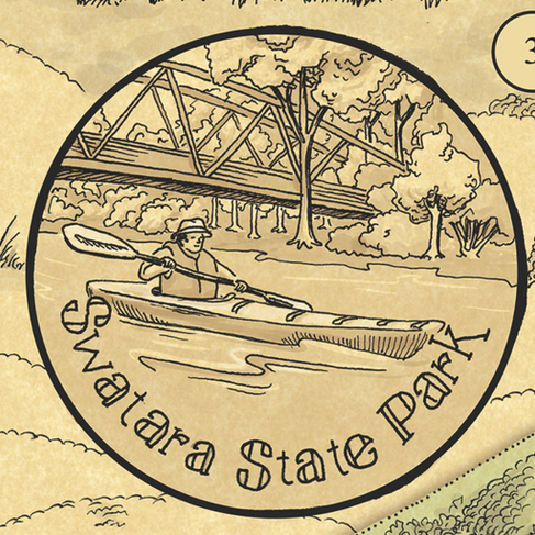
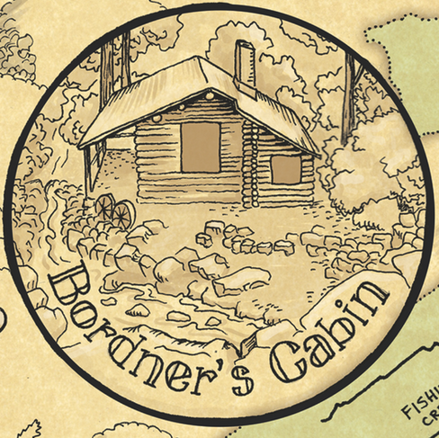
The four special “Point of Interest” illustrations were chosen by myself and Bethany as well. The seventeen triangular boat launch markers were placed based on Swatara Watershed Association's information. The “Point of Interest” and boat launch markers invite viewers to engage with the river in person at these particular points.


To draw the illustrated parts within the map, I collected multiple reference photos of each plant, animal, and place. Many of the reference photos came from my own camera.
I then sketched each animal onto large sheet of paper that I had drawn the water ways on already, adjusting the placements and poses to fit into the page layout just right. This original pencil drawing is 22” wide and 25” tall.

Once the pencil sketch was complete, I laid a 22”x25” piece of Layout Bond ontop of the white paper. Layout Bond in a lightweight, semi-translucent paper that is ideal for use with pen and ink. I drew the entire map with Micron pens and brushes on the Layout Bond while using the original pencil drawing underneath as a faint guide. To make sure each portion of the map had the correct line width, I jotted down a quick guide noting which pen thickness I was using for each part of the map.


After hours of drawing, I scanned the final inked piece into the computer at a very high resolution and cleaned up the file. I digitally layered the inked drawing on top of parchment paper. Coloring the piece digitally, I was able to create the green background for the watershed and the browns found within the plants and animals. I also added the text within the Species List and the information in the lower right hand corner. All other lettering was written by hand by yours truly.

Enjoy the map!
Thanks to Pennsylvania Environmental Council and Swatara Watershed Association for support in creating this piece. Financial and technical assistance for this project was provided by National Park Service Chesapeake Gateways. Chesapeake Gateways inspires and helps people discover, experience, and connect with the natural and cultural heritage and recreational opportunities of the Chesapeake Bay and the rivers, landscapes, and communities across its watershed.
Interested in getting a copy? Check out my online shop listing below. Because of the Residency's contract, the price will remain lower than other comparable items in my shop. Lucky you!


Comments